113 W Trinity Street
Madisonville, TX 77864
Phone: 936-349-0163
Copyright © 2017-2025 Madison County Economic
Development Corporation
ALL RIGHTS RESERVED
Web Design by MAD WEB DESIGNERS
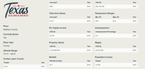
Estimated Population
Annual Growth Rate
Businesses in Madison CO.
5-Year Job Growth
14,284
1.9%
260
4.8%
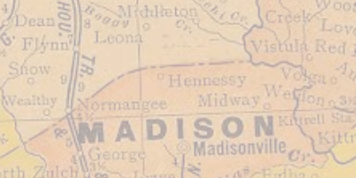
Madison
County
is
located
in
central
East
Texas.
Madisonville,
the
county
seat
and
largest
town,
is
near
interstate
Highway
45
about
100
miles
northwest
of
Houston;
the
town
is
at
30°57'
north
latitude
and
95°55'
west
longitude,
close
to
the
center
of
the
county.
Madison
County
includes
473
square
miles
primarily
of
post
oak
savannah,
a
mixture
of
post
oak
woods
and
grasslands.
The
northeast
and
south
central
parts
of
the
county
are
in
the
Blackland
Prairies
region;
the
southeast
corner
of
the
county
lies
in
the
Piney
Woods.
Today,
about
one-fifth
of
the
area
is
timbered,
but
early
reports
describe
it
as
two-
thirds timber and one-third prairie.


Our History
The
judicial
Madison
County
was
formed
on
February
2,
1842,
from
Montgomery
County.
(Judicial
counties
were
later
declared
unconstitutional
because
they
had
no
legislative
representation.)
Because
residents
of
the
northern
parts
of
Walker
and
Grimes
counties
lived
forty
to
fifty
miles
from
their
county
seats,
they
petitioned
the
legislature
for
the
establishment
of
a
new
county.
The
formation
of
Madison
County
from
Grimes,
Walker,
and
Leon
counties
was
approved
on
January
27,
1853,
and
organization
followed
on
August
7,
1854.
The
raising
of
beef
cattle,
long
a
major
activity
in
Madison
County,
remains
the
primary
source
of
agricultural
income.
The
county
had
16,110
head
in
1860
and
maintained
similar
numbers
through
the
1920s;
cattle
declined
by
1930
to
9,876.
The
1940s
saw
the
beginning
of
a
recovery
in
the
industry;
54,288
cattle
were
enumerated
in
the
county
in
1950
and
31,919 in 1987.
The
construction
of
Interstate
Highway
45
through
Madison
County,
which
began
in
1962,
brought
a
short
period
of
prosperity
to
the
county.
A
substantial
decline
occurred
after
its
completion
in
1965,
however,
as
jobs
and
trade
that
had
been
generated by the construction were lost.
.
Of
numerous
early
settlements,
only
three
flourished.
Midway,
the
oldest
town
in
Madison
County,
was
settled
in
1829
by
J.
H.
Young.
It
was
located
in
the
eastern
end
of
the
county
approximately
three
miles
from
the
Trinity
River
and
named
Midway
in
1855,
when
Professor
Joseph
A.
Clark
arrived
from
Midway, Kentucky.
Madison
County,
reported
to
have
been
"wild
and
wooly"
before
and
after
the
Civil
War,
was
referred
to
as
the
"Free
State
of
Madison."
Between
1854
and
1873
the
county
lost
three
courthouses
to
fire,
and
in
1967
yet
another
courthouse
burned
to
the
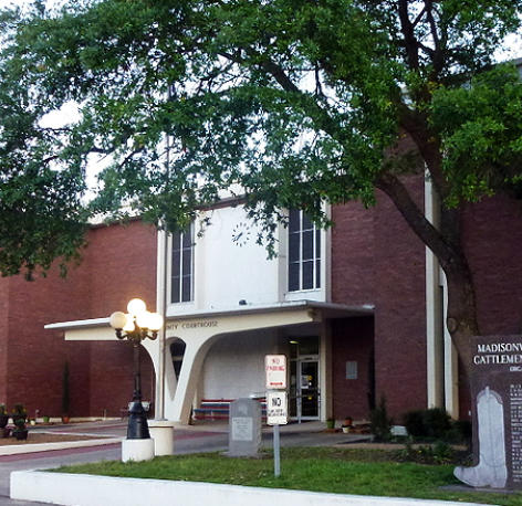
ground.
The
present
building
was
completed
in
1970.
The
railroad
reached
Madison
County
in
1903,
when
the
International-Great
Northern
Railway
Company
extended
a
branch
line
from
Navasota
to
Madisonville.
In
the
1980s
the
county
was
served
by
the
Joint
Texas
Division
main
line
running
between
Dallas
and
Houston,
operated
by
a
partnership
of
the
Burlington
Northern
and
Chicago,
Rock
Island
Pacific
lines.
By
the
early
twenty-first
century
the
line
was
operated
by
the
Burlington Northern Santa Fe.
The
oil
boom
of
the
1980s
again
brought
temporary
prosperity
to
the
county.
Oil
was
discovered
in
1946,
and
the
county
has
generally
ranked
in
the
middle
range
of
producing
counties
in
Texas.
In
the
early
1980s
the
county
ranked
in
the
top
third
of
Texas
counties
in
oil
production,
yet
still
substantially
below
the
largest
producers.
As
the
market
fell
off,
however,
Madison
County's
petroleum-related
activities
shared
the
decline
of
the
rest
of
the
Texas
oil
industry.
Almost
416,000
barrels
of
oil
and
8,683,569
cubic
feet
of
gas-well
gas
were
produced
in
the
county
in
2004;
by
the
end
of
that
year
32,985,267
barrels
of
oil
had been taken from county lands since 1946.
In
the
early
twenty-first
century
agribusiness,
oil
production,
and
a
state
prison
were
key
elements
of
the
area's
economy.
In
2002
the
county
had
890
farms
and
ranches
covering
244,524
acres,
52
percent
of
which
were
devoted
to
pasture,
38
percent
to
crops,
and
8
percent
to
woodlands.
In
that
year
local
farmers
and ranchers earned $15,829,000.


Madison County at a Glance
EST. U.S. Census Bureau and Bureau of Labor Statistics
(2019).



MADISON COUNTY

Court House
1896
Court House
2020


1829
1842
1854
1860
1903
1962
1980
2002


Information reprinted from
Today
Madison County is crossed by Interstate Highway 45 and has a road network that in 2002 totaled 507 lane
miles. One public airport provides service to the county. Madisonville (population, 4,708) is the county's
seat of government and largest town; other communities include Midway (236), North Zulch (600), and
Normangee (668, mostly in Leon County). The scenic Texas Brazos Trail runs through Madison County, and
Madisonville hosts the Texas Mushroom Festival in October.
Madison County is located in central East Texas. Madisonville, the county seat and largest town, is near interstate Highway 45
about 100 miles northwest of Houston; the town is at 30°57' north latitude and 95°55' west longitude, close to the center of
the county. Madison County includes 473 square miles primarily of post oak savannah, a mixture of post oak woods and
grasslands. The northeast and south central parts of the county are in the Blackland Prairies region; the southeast corner of
the county lies in the Piney Woods. Today, about one-fifth of the area is timbered, but early reports describe it as two-thirds
timber and one-third prairie. It supported oak, cedar, elm, walnut, hickory, gum, pecan, ash, cypress, and pine. The terrain is
undulating, with an elevation ranging from 213 to 364 feet above sea level. The rolling prairies drain to the waterways that
form the county's boundaries: the Trinity River in the east, the Navasota River in the west, and Bedias Creek in the south.
Numerous other creeks run through the county, notably the Caney, which bisects it. Several soil types are found in the county,
which lies principally in the Claypan area. They range from black waxy to light sandy loam around creeks and lower lands, with
dark chocolate mixed with sand on the prairie uplands. Almost the entire county is made up of soils with sandy surface layers
and mottled yellow, red, and gray loamy subsoils. The northwest portion is surfaced by noncalcareous and calcareous cracking
clayey soils and slightly acid soils with loamy surface layers and cracking clayey subsoils. Oil and gas are found in the county, as
are lignite, sand, and gravel. Madison County has a mild climate, with an average growing season of 272 days. Its average
annual rainfall is 41.50 inches, and temperatures range from a January minimum average of 40° F to a July maximum average
of 94°.
The territory in present-day Madison County was occupied by members of two Indian groups, the Caddoes and the Atakapans.
The Caddoes were among the most advanced of the Texas Indians and were considered wealthy as well as friendly. They lived
in large villages and constructed beehive-shaped houses. The Bidais, who were the principal residents of the area now known
as Madison County, belonged to the Atakapan group. They, along with the Deadose Indians, themselves also Atakapans,
occupied the Trinity River valley in the heart of the county. The main village of the Bidais was located at the confluence of the
Trinity River and Bedias Creek. Closely associated with the Caddoes, the Bidais were agriculturalists, known for raising corn.
They also depended largely on hunting, especially of deer. Though they were never a large group, they were decimated by
epidemics and incursions by hostile tribes. The Kickapoos, migrants from the east who settled among the remnants of the
Caddo confederacies, also resided in the area at one time; Kickapoo Creek still bears their name.
Settlement of the future Madison County began in Spanish Texas. The first European explorers known to have reached the
area were Luis de Moscoso Alvarado and Robert Cavelier, Sieur de La Salle. Moscoso, a member of Hernando De Soto's
expedition who continued on in 1542 after De Soto's death, eventually reached the southeastern part of the future Madison
County and traveled along what became the La Bahía Road. La Salle is thought to have crossed southeastern Madison County
in 1687, and some believe he was killed in Madison County, at a site just south of Madisonville. The La Bahía Road and the Old
San Antonio Road, originally Indian trails, passed through what is now Madison County. The former led southwest to
Washington-on-the-Brazos, Gonzales, and Goliad, diverging from the Old San Antonio Road at a point not far from where the
two crossed the Trinity. The Old San Antonio Road, which forms a major portion of the county's northern boundary, continued
through Bastrop on its way from Nacogdoches to San Antonio. A Spanish settlement was established in Madison County in
1774, on the banks of the Trinity at the crossing of the two Spanish roads. The site, known as Paso Tomás, was near the main
village of the Bidais. The settlement comprised a group of families resettled from Los Adaes by Governor Juan María de
Ripperdá and led by Antonio Gil Ibarvo. The reasons given by Ripperdá for the selection of the site were its central location on
the highway from Bexar to Natchitoches, the agricultural promise of the region, the fact that it was buffered from hostile
Indians by the presence of friendly tribes, the opportunity to conduct missionary work among the local tribes, and its useful
situation for the observation and interdiction of the French contraband trade, as well as the protection of the Gulf Coast from
the English. The settlement was named Nuestra Señora del Pilar de Bucareli, and was called Bucareli. Fears of Comanche
attack led many to abandon the settlement in January 1779; flooding of the Trinity in February dealt the final blow. The
inhabitants returned eastward to the vicinity of the old mission at Nacogdoches. The site of Bucareli was later occupied by
Robbins's Ferry. In 1805 the settlement of Trinidad, or Spanish Bluff, was established by Spanish soldiers sent by Governor
Manuel Antonio Cordero y Bustamante to regain possession of territory claimed by the United States. This settlement was
sacked by members of the Gutiérrez-Magee expedition in 1812. After the failure of the expedition, some of its members were
captured at Spanish Bluff and executed by the Spanish commander, Ignacio Elizondo.
In the future Madison County three empresario grants of the Mexican government (Austin, Vehlein, and Burnet) joined. José
Miguel Músquiz received the first grant, which was situated partially in the Vehlein colony, in 1831. Major W. C. Young is
generally agreed to have been the first Anglo-American to settle permanently in the area. He left South Carolina in 1829 and
moved to Texas, where he participated in the battle of San Jacinto. Prominent among other early settlers and instrumental in
settlement and development were James Mitchell, Job Starks Collard, and Dr. Pleasant W. Kittrell. Mitchell kept a well-regarded
hostelry at the parting of the San Antonio and La Bahía roads and established the first post office in Madison County. Collard, a
member of the Austin colony, was granted a league of land by the Mexican government on May 28, 1835. In 1853 he donated
200 acres for the establishment of a townsite, on which the county seat, Madisonville, was founded. Kittrell was the impetus
behind the organization of Madison County.
The judicial Madison County was formed on February 2, 1842, from Montgomery County. (Judicial counties were later declared
unconstitutional because they had no legislative representation.) Because residents of the northern parts of Walker and
Grimes counties lived forty to fifty miles from their county seats, they petitioned the legislature for the establishment of a new
county. The formation of Madison County from Grimes, Walker, and Leon counties was approved on January 27, 1853, and
organization followed on August 7, 1854. Kittrell was instrumental in this effort, and became the county's first representative in
the legislature. He selected the site for the county seat, which was preferred because of its central location; he named the
county and its seat for the nation's fourth president, James Madison. Dr. Kittrell was also Sam Houston's physician and was in
attendance at the general's death.
Of numerous early settlements, only three flourished. Midway, the oldest town in Madison County, was settled in 1829 by J. H.
Young. It was located in the eastern end of the county approximately three miles from the Trinity River and named Midway in
1855, when Professor Joseph A. Clark arrived from Midway, Kentucky. North Zulch, in the west end of the county, was named
for Julius Zulch, who emigrated from Germany in 1848 and founded the settlement named Zulch. Around 1906, the community
moved to the railroad and became North Zulch. Madisonville, the county seat, was established upon the formation of the
county, in compliance with the legislature's ruling that county seats be no more than five miles removed from the centers of
the counties. By 1854 Elwood, one of the largest communities in the county, was a rival to Madisonville for designation as the
county seat. But after being passed over, it did not continue to prosper. Rogers Prairie, on the Old San Antonio Road, was
settled in 1835 by Robert Rogers, who had received a land grant from the Mexican government. When bypassed by the Trinity
and Brazos Valley Railway in 1906, the settlement moved 1.6 miles westward; it eventually became Normangee.
Settlers in the future Madison County witnessed the Runaway Scrape in 1836, as citizens of Texas rushed toward the Trinity in
an effort to escape the advance of Santa Anna. News of the victory at San Jacinto caused them to turn back before many had
crossed the river. Madison County, reported to have been "wild and wooly" before and after the Civil War, was referred to as
the "Free State of Madison." Between 1854 and 1873 the county lost three courthouses to fire, and in 1967 yet another
courthouse burned to the ground. The present building was completed in 1970.
Madison County has always been primarily agricultural and rural. Crop production, once the primary means of subsistence,
dropped off sharply after 1959 in almost every category. In 1987 the number of farms operating was 756, only 32 percent of
the total of 2,355 reported in the peak year of 1930. The former staple crops, corn, cotton, and sweet potatoes, no longer
contribute significantly to agricultural income. Cotton production was 12,196 bales in the peak year, 1900, but yields
diminished gradually to 2,435 bales in 1959 before dropping to zero in 1982. Corn harvests increased dramatically, from 65,225
bushels in 1860 to 589,202 bushels in 1920, then dropped to 189,364 bushels in 1930. Although production of corn recovered
to 336,326 bushels in 1940, it decreased steadily until reaching an insignificant level in 1987. Sweet potato cultivation, which
yielded 5,512 bushels in 1860, exhibited erratic levels of production. The yield was 2,933 bushels in 1880, 37,283 bushels in
1890, 8,583 bushels in 1910, and 24,959 bushels in 1920. After remaining stable from 1930 through the 1950s, the sweet
potato yield fell to zero in 1969. Wool, also an important agricultural product in Madison County before 1900, yielded 11,676
tons in 1890, but was no longer produced by 1969. Until the 1950s, poultry production and the dairy industry contributed
substantially to agricultural production in the county, but subsequently lost importance. Madison County had 6,806 milk cows
in 1920, but only 277 in 1987. Reported fowl numbered 90,602 in 1920 and 642 in 1987.
The raising of beef cattle, long a major activity in Madison County, remains the primary source of agricultural income. The
county had 16,110 head in 1860 and maintained similar numbers through the 1920s; cattle declined by 1930 to 9,876. The
1940s saw the beginning of a recovery in the industry; 54,288 cattle were enumerated in the county in 1950 and 31,919 in
1987. An increase in the cultivation of hay and forage crops accompanied the growing numbers of cattle, rising from 1,348 tons
in 1940 to 73,445 tons in 1987. Horse raising also grew in importance. Swine raising, which dropped from 11,021 in 1920 to
5,124 in 1930, remained steady afterward; 4,640 head were reported in 1987.
MADISON COUNTY
113 W Trinity Street
Madisonville, TX 77864
Phone: 936-349-0163
Copyright © 2017-2025 Madison County Economic
Development Corporation
ALL RIGHTS RESERVED
Web Design by MAD WEB DESIGNERS
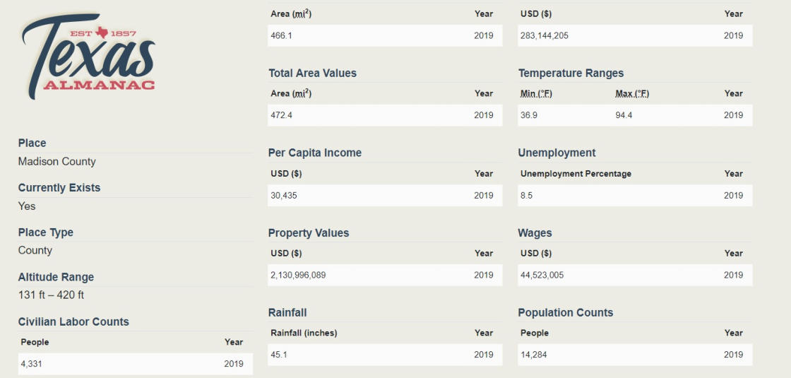
Estimated Population
Annual Growth
Rate
Businesses in Madison CO.
5-Year Job
Growth
14,284
1.9%
260
4.8%
Madison
County
is
located
in
central
East
Texas.
Madisonville,
the
county
seat
and
largest
town,
is
near
interstate
Highway
45
about
100
miles
northwest
of
Houston;
the
town
is
at
30°57'
north
latitude
and
95°55'
west
longitude,
close
to
the
center
of
the
county.
Madison
County
includes
473
square
miles
primarily
of
post
oak
savannah,
a
mixture
of
post
oak
woods
and
grasslands.
The
northeast
and
south
central
parts
of
the
county
are
in
the
Blackland
Prairies
region;
the
southeast
corner
of
the
county
lies
in
the
Piney
Woods.
Today,
about
one-fifth
of
the
area
is
timbered,
but
early
reports describe it as two-thirds timber and one-third prairie.


Our History
The
judicial
Madison
County
was
formed
on
February
2,
1842,
from
Montgomery
County.
(Judicial
counties
were
later
declared
unconstitutional
because
they
had
no
legislative
representation.)
Because
residents
of
the
northern
parts
of
Walker
and
Grimes
counties
lived
forty
to
fifty
miles
from
their
county
seats,
they
petitioned
the
legislature
for
the
establishment
of
a
new
county.
The
formation
of
Madison
County
from
Grimes,
Walker,
and
Leon
counties
was approved on January 27, 1853, and organization followed on August 7, 1854.
The
raising
of
beef
cattle,
long
a
major
activity
in
Madison
County,
remains
the
primary
source
of
agricultural
income.
The
county
had
16,110
head
in
1860
and
maintained
similar
numbers
through
the
1920s;
cattle
declined
by
1930
to
9,876.
The
1940s
saw
the
beginning
of
a
recovery
in the industry; 54,288 cattle were enumerated in the county in 1950 and 31,919 in 1987.
The
construction
of
Interstate
Highway
45
through
Madison
County,
which
began
in
1962,
brought
a
short
period
of
prosperity
to
the
county.
A
substantial
decline
occurred
after
its
completion
in
1965,
however,
as
jobs
and
trade
that
had
been
generated
by
the
construction
were lost.
.
Today
Madison County is crossed by Interstate Highway 45 and has a road network that in 2002
totaled 507 lane miles. One public airport provides service to the county. Madisonville
(population, 4,708) is the county's seat of government and largest town; other communities
include Midway (236), North Zulch (600), and Normangee (668, mostly in Leon County). The
scenic Texas Brazos Trail runs through Madison County, and Madisonville hosts the Texas
Mushroom Festival in October.
Of
numerous
early
settlements,
only
three
flourished.
Midway,
the
oldest
town
in
Madison
County,
was
settled
in
1829
by
J.
H.
Young.
It
was
located
in
the
eastern
end
of
the
county
approximately
three
miles
from
the
Trinity
River
and
named
Midway
in
1855,
when
Professor
Joseph A. Clark arrived from Midway, Kentucky.
Madison
County,
reported
to
have
been
"wild
and
wooly"
before
and
after
the
Civil
War,
was
referred
to
as
the
"Free
State
of
Madison."
Between
1854
and
1873
the
county
lost
three
courthouses
to
fire,
and
in
1967
yet
another
courthouse
burned
to
the
ground.
The
present
building was completed in 1970.
The
railroad
reached
Madison
County
in
1903,
when
the
International-Great
Northern
Railway
Company
extended
a
branch
line
from
Navasota
to
Madisonville.
In
the
1980s
the
county
was
served
by
the
Joint
Texas
Division
main
line
running
between
Dallas
and
Houston,
operated
by
a
partnership
of
the
Burlington
Northern
and
Chicago,
Rock
Island
Pacific
lines.
By
the
early
twenty-first century the line was operated by the Burlington Northern Santa Fe.
The
oil
boom
of
the
1980s
again
brought
temporary
prosperity
to
the
county.
Oil
was
discovered
in
1946,
and
the
county
has
generally
ranked
in
the
middle
range
of
producing
counties
in
Texas.
In
the
early
1980s
the
county
ranked
in
the
top
third
of
Texas
counties
in
oil
production,
yet
still
substantially
below
the
largest
producers.
As
the
market
fell
off,
however,
Madison
County's
petroleum-related
activities
shared
the
decline
of
the
rest
of
the
Texas
oil
industry.
Almost
416,000
barrels
of
oil
and
8,683,569
cubic
feet
of
gas-well
gas
were
produced
in
the
county
in
2004;
by
the
end
of
that
year
32,985,267
barrels
of
oil
had
been
taken
from
county lands since 1946.


Madison County at a Glance
EST. U.S. Census Bureau and Bureau of Labor Statistics
(2019).


MADISON COUNTY

Court House
1896
Court House
2020
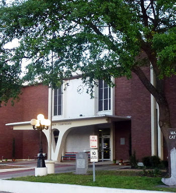
1829
1842
1854
1860
1903
1962
1980
2002
In
the
early
twenty-first
century
agribusiness,
oil
production,
and
a
state
prison
were
key
elements
of
the
area's
economy.
In
2002
the
county
had
890
farms
and
ranches
covering
244,524
acres,
52
percent
of
which
were
devoted
to
pasture,
38
percent
to
crops,
and
8
percent
to woodlands. In that year local farmers and ranchers earned $15,829,000.
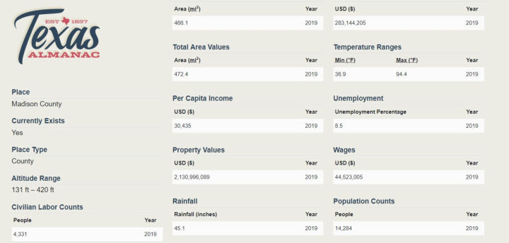

Information reprinted from
Madison County is located in central East Texas. Madisonville, the county seat and largest town,
is near interstate Highway 45 about 100 miles northwest of Houston; the town is at 30°57' north
latitude and 95°55' west longitude, close to the center of the county. Madison County includes
473 square miles primarily of post oak savannah, a mixture of post oak woods and grasslands.
The northeast and south central parts of the county are in the Blackland Prairies region; the
southeast corner of the county lies in the Piney Woods. Today, about one-fifth of the area is
timbered, but early reports describe it as two-thirds timber and one-third prairie. It supported
oak, cedar, elm, walnut, hickory, gum, pecan, ash, cypress, and pine. The terrain is undulating,
with an elevation ranging from 213 to 364 feet above sea level. The rolling prairies drain to the
waterways that form the county's boundaries: the Trinity River in the east, the Navasota River in
the west, and Bedias Creek in the south. Numerous other creeks run through the county,
notably the Caney, which bisects it. Several soil types are found in the county, which lies
principally in the Claypan area. They range from black waxy to light sandy loam around creeks
and lower lands, with dark chocolate mixed with sand on the prairie uplands. Almost the entire
county is made up of soils with sandy surface layers and mottled yellow, red, and gray loamy
subsoils. The northwest portion is surfaced by noncalcareous and calcareous cracking clayey
soils and slightly acid soils with loamy surface layers and cracking clayey subsoils. Oil and gas
are found in the county, as are lignite, sand, and gravel. Madison County has a mild climate, with
an average growing season of 272 days. Its average annual rainfall is 41.50 inches, and
temperatures range from a January minimum average of 40° F to a July maximum average of
94°.
The territory in present-day Madison County was occupied by members of two Indian groups,
the Caddoes and the Atakapans. The Caddoes were among the most advanced of the Texas
Indians and were considered wealthy as well as friendly. They lived in large villages and
constructed beehive-shaped houses. The Bidais, who were the principal residents of the area
now known as Madison County, belonged to the Atakapan group. They, along with the Deadose
Indians, themselves also Atakapans, occupied the Trinity River valley in the heart of the county.
The main village of the Bidais was located at the confluence of the Trinity River and Bedias
Creek. Closely associated with the Caddoes, the Bidais were agriculturalists, known for raising
corn. They also depended largely on hunting, especially of deer. Though they were never a large
group, they were decimated by epidemics and incursions by hostile tribes. The Kickapoos,
migrants from the east who settled among the remnants of the Caddo confederacies, also
resided in the area at one time; Kickapoo Creek still bears their name.
Settlement of the future Madison County began in Spanish Texas. The first European explorers
known to have reached the area were Luis de Moscoso Alvarado and Robert Cavelier, Sieur de
La Salle. Moscoso, a member of Hernando De Soto's expedition who continued on in 1542 after
De Soto's death, eventually reached the southeastern part of the future Madison County and
traveled along what became the La Bahía Road. La Salle is thought to have crossed
southeastern Madison County in 1687, and some believe he was killed in Madison County, at a
site just south of Madisonville. The La Bahía Road and the Old San Antonio Road, originally
Indian trails, passed through what is now Madison County. The former led southwest to
Washington-on-the-Brazos, Gonzales, and Goliad, diverging from the Old San Antonio Road at a
point not far from where the two crossed the Trinity. The Old San Antonio Road, which forms a
major portion of the county's northern boundary, continued through Bastrop on its way from
Nacogdoches to San Antonio. A Spanish settlement was established in Madison County in 1774,
on the banks of the Trinity at the crossing of the two Spanish roads. The site, known as Paso
Tomás, was near the main village of the Bidais. The settlement comprised a group of families
resettled from Los Adaes by Governor Juan María de Ripperdá and led by Antonio Gil Ibarvo.
The reasons given by Ripperdá for the selection of the site were its central location on the
highway from Bexar to Natchitoches, the agricultural promise of the region, the fact that it was
buffered from hostile Indians by the presence of friendly tribes, the opportunity to conduct
missionary work among the local tribes, and its useful situation for the observation and
interdiction of the French contraband trade, as well as the protection of the Gulf Coast from the
English. The settlement was named Nuestra Señora del Pilar de Bucareli, and was called
Bucareli. Fears of Comanche attack led many to abandon the settlement in January 1779;
flooding of the Trinity in February dealt the final blow. The inhabitants returned eastward to the
vicinity of the old mission at Nacogdoches. The site of Bucareli was later occupied by Robbins's
Ferry. In 1805 the settlement of Trinidad, or Spanish Bluff, was established by Spanish soldiers
sent by Governor Manuel Antonio Cordero y Bustamante to regain possession of territory
claimed by the United States. This settlement was sacked by members of the Gutiérrez-Magee
expedition in 1812. After the failure of the expedition, some of its members were captured at
Spanish Bluff and executed by the Spanish commander, Ignacio Elizondo.
In the future Madison County three empresario grants of the Mexican government (Austin,
Vehlein, and Burnet) joined. José Miguel Músquiz received the first grant, which was situated
partially in the Vehlein colony, in 1831. Major W. C. Young is generally agreed to have been the
first Anglo-American to settle permanently in the area. He left South Carolina in 1829 and
moved to Texas, where he participated in the battle of San Jacinto. Prominent among other early
settlers and instrumental in settlement and development were James Mitchell, Job Starks
Collard, and Dr. Pleasant W. Kittrell. Mitchell kept a well-regarded hostelry at the parting of the
San Antonio and La Bahía roads and established the first post office in Madison County. Collard,
a member of the Austin colony, was granted a league of land by the Mexican government on
May 28, 1835. In 1853 he donated 200 acres for the establishment of a townsite, on which the
county seat, Madisonville, was founded. Kittrell was the impetus behind the organization of
Madison County.
The judicial Madison County was formed on February 2, 1842, from Montgomery County.
(Judicial counties were later declared unconstitutional because they had no legislative
representation.) Because residents of the northern parts of Walker and Grimes counties lived
forty to fifty miles from their county seats, they petitioned the legislature for the establishment
of a new county. The formation of Madison County from Grimes, Walker, and Leon counties was
approved on January 27, 1853, and organization followed on August 7, 1854. Kittrell was
instrumental in this effort, and became the county's first representative in the legislature. He
selected the site for the county seat, which was preferred because of its central location; he
named the county and its seat for the nation's fourth president, James Madison. Dr. Kittrell was
also Sam Houston's physician and was in attendance at the general's death.
Of numerous early settlements, only three flourished. Midway, the oldest town in Madison
County, was settled in 1829 by J. H. Young. It was located in the eastern end of the county
approximately three miles from the Trinity River and named Midway in 1855, when Professor
Joseph A. Clark arrived from Midway, Kentucky. North Zulch, in the west end of the county, was
named for Julius Zulch, who emigrated from Germany in 1848 and founded the settlement
named Zulch. Around 1906, the community moved to the railroad and became North Zulch.
Madisonville, the county seat, was established upon the formation of the county, in compliance
with the legislature's ruling that county seats be no more than five miles removed from the
centers of the counties. By 1854 Elwood, one of the largest communities in the county, was a
rival to Madisonville for designation as the county seat. But after being passed over, it did not
continue to prosper. Rogers Prairie, on the Old San Antonio Road, was settled in 1835 by Robert
Rogers, who had received a land grant from the Mexican government. When bypassed by the
Trinity and Brazos Valley Railway in 1906, the settlement moved 1.6 miles westward; it
eventually became Normangee.
Settlers in the future Madison County witnessed the Runaway Scrape in 1836, as citizens of
Texas rushed toward the Trinity in an effort to escape the advance of Santa Anna. News of the
victory at San Jacinto caused them to turn back before many had crossed the river. Madison
County, reported to have been "wild and wooly" before and after the Civil War, was referred to
as the "Free State of Madison." Between 1854 and 1873 the county lost three courthouses to
fire, and in 1967 yet another courthouse burned to the ground. The present building was
completed in 1970.
Madison County has always been primarily agricultural and rural. Crop production, once the
primary means of subsistence, dropped off sharply after 1959 in almost every category. In 1987
the number of farms operating was 756, only 32 percent of the total of 2,355 reported in the
peak year of 1930. The former staple crops, corn, cotton, and sweet potatoes, no longer
contribute significantly to agricultural income. Cotton production was 12,196 bales in the peak
year, 1900, but yields diminished gradually to 2,435 bales in 1959 before dropping to zero in
1982. Corn harvests increased dramatically, from 65,225 bushels in 1860 to 589,202 bushels in
1920, then dropped to 189,364 bushels in 1930. Although production of corn recovered to
336,326 bushels in 1940, it decreased steadily until reaching an insignificant level in 1987. Sweet
potato cultivation, which yielded 5,512 bushels in 1860, exhibited erratic levels of production.
The yield was 2,933 bushels in 1880, 37,283 bushels in 1890, 8,583 bushels in 1910, and 24,959
bushels in 1920. After remaining stable from 1930 through the 1950s, the sweet potato yield fell
to zero in 1969. Wool, also an important agricultural product in Madison County before 1900,
yielded 11,676 tons in 1890, but was no longer produced by 1969. Until the 1950s, poultry
production and the dairy industry contributed substantially to agricultural production in the
county, but subsequently lost importance. Madison County had 6,806 milk cows in 1920, but
only 277 in 1987. Reported fowl numbered 90,602 in 1920 and 642 in 1987.
The raising of beef cattle, long a major activity in Madison County, remains the primary source
of agricultural income. The county had 16,110 head in 1860 and maintained similar numbers
through the 1920s; cattle declined by 1930 to 9,876. The 1940s saw the beginning of a recovery
in the industry; 54,288 cattle were enumerated in the county in 1950 and 31,919 in 1987. An
increase in the cultivation of hay and forage crops accompanied the growing numbers of cattle,
rising from 1,348 tons in 1940 to 73,445 tons in 1987. Horse raising also grew in importance.
Swine raising, which dropped from 11,021 in 1920 to 5,124 in 1930, remained steady afterward;
4,640 head were reported in 1987.
MADISON COUNTY
![Close [x]](index_htm_files/close.png)
113 W Trinity Street
Madisonville, TX 77864
Phone: 936-349-0163
Copyright © 2017-2025 Madison County Economic
Development Corporation
Web Design by MAD WEB DESIGNERS
Madison
County
is
located
in
central
East
Texas.
Madisonville,
the
county
seat
and
largest
town,
is
near
interstate
Highway
45
about
100
miles
northwest
of
Houston;
the
town
is
at
30°57'
north
latitude
and
95°55'
west
longitude,
close
to
the
center
of
the
county.
Madison
County
includes
473
square
miles
primarily
of
post
oak
savannah,
a
mixture
of
post
oak
woods
and
grasslands.
The
northeast
and
south
central
parts
of
the
county
are
in
the
Blackland
Prairies
region;
the
southeast
corner
of
the
county
lies
in
the
Piney
Woods.
Today,
about
one-fifth
of
the
area
is
timbered,
but
early
reports
describe
it
as
two-thirds timber and one-third prairie.
Our History

Information reprinted from


MADISON COUNTY

Court House
1896
Court House
2020
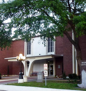
1829
1842
1854
1860
1903
1962
1980
2002

Madison County
at a Glance
EST. U.S. Census Bureau and Bureau of Labor Statistics
(2019).
Estimated Population
Annual Growth Rate
Businesses in Madison CO.
5-Year Job Growth
14,284
1.9%
260
4.8%
The
judicial
Madison
County
was
formed
on
February
2,
1842,
from
Montgomery
County.
(Judicial
counties
were
later
declared
unconstitutional
because
they
had
no
legislative
representation.)
Because
residents
of
the
northern
parts
of
Walker
and
Grimes
counties
lived
forty
to
fifty
miles
from
their
county
seats,
they
petitioned
the
legislature
for
the
establishment
of
a
new
county.
The
formation
of
Madison
County
from
Grimes,
Walker,
and
Leon
counties
was
approved
on
January
27,
1853,
and
organization followed on August 7, 1854.
Of
numerous
early
settlements,
only
three
flourished.
Midway,
the
oldest
town
in
Madison
County,
was
settled
in
1829
by
J.
H.
Young.
It
was
located
in
the
eastern
end
of
the
county
approximately
three
miles
from
the
Trinity
River
and
named
Midway
in
1855,
when
Professor
Joseph A. Clark arrived from Midway, Kentucky.
Madison
County,
reported
to
have
been
"wild
and
wooly"
before
and
after
the
Civil
War,
was
referred
to
as
the
"Free
State
of
Madison."
Between
1854
and
1873
the
county
lost
three
courthouses
to
fire,
and
in
1967
yet
another
courthouse
burned
to
the
ground.
The
present
building was completed in 1970.
Today
Madison County is crossed by Interstate Highway
45 and has a road network that in 2002 totaled
507 lane miles. One public airport provides service
to the county. Madisonville (population, 4,708) is
the county's seat of government and largest town;
other communities include Midway (236), North
Zulch (600), and Normangee (668, mostly in Leon
County). The scenic Texas Brazos Trail runs
through Madison County, and Madisonville hosts
the Texas Mushroom Festival in October.
In
the
early
twenty-first
century
agribusiness,
oil
production,
and
a
state
prison
were
key
elements
of
the
area's
economy.
In
2002
the
county
had
890
farms
and
ranches
covering
244,524
acres,
52
percent
of
which
were
devoted
to
pasture,
38
percent
to
crops,
and
8
percent
to
woodlands.
In
that
year
local
farmers
and
ranchers
earned
$15,829,000.
The
raising
of
beef
cattle,
long
a
major
activity
in
Madison
County,
remains
the
primary
source
of
agricultural
income.
The
county
had
16,110
head
in
1860
and
maintained
similar
numbers
through
the
1920s;
cattle
declined
by
1930
to
9,876.
The
1940s
saw
the
beginning
of
a
recovery
in
the
industry;
54,288
cattle
were
enumerated
in
the
county in 1950 and 31,919 in 1987.
The
construction
of
Interstate
Highway
45
through
Madison
County,
which
began
in
1962,
brought
a
short
period
of
prosperity
to
the
county.
A
substantial
decline
occurred
after
its
completion
in
1965,
however,
as
jobs
and
trade
that
had
been
generated
by
the
construction
were lost.
.
The
railroad
reached
Madison
County
in
1903,
when
the
International-Great
Northern
Railway
Company
extended
a
branch
line
from
Navasota
to
Madisonville.
In
the
1980s
the
county
was
served
by
the
Joint
Texas
Division
main
line
running
between
Dallas
and
Houston,
operated
by
a
partnership
of
the
Burlington
Northern
and
Chicago,
Rock
Island
Pacific
lines.
By
the
early
twenty-first
century
the
line
was
operated
by
the
Burlington Northern Santa Fe.
The
oil
boom
of
the
1980s
again
brought
temporary
prosperity
to
the
county.
Oil
was
discovered
in
1946,
and
the
county
has
generally
ranked
in
the
middle
range
of
producing
counties
in
Texas.
In
the
early
1980s
the
county
ranked
in
the
top
third
of
Texas
counties
in
oil
production,
yet
still
substantially
below
the
largest
producers.
As
the
market
fell
off,
however,
Madison
County's
petroleum-related
activities
shared
the
decline
of
the
rest
of
the
Texas
oil
industry.
Almost
416,000
barrels
of
oil
and
8,683,569
cubic
feet
of
gas-well
gas
were
produced
in
the
county
in
2004;
by
the
end
of
that
year
32,985,267
barrels
of
oil
had
been taken from county lands since 1946.


